
The 4 Types Of Flooding In The UK: Rivers And Sea, Surface Water, Groundwater And Reservoirs
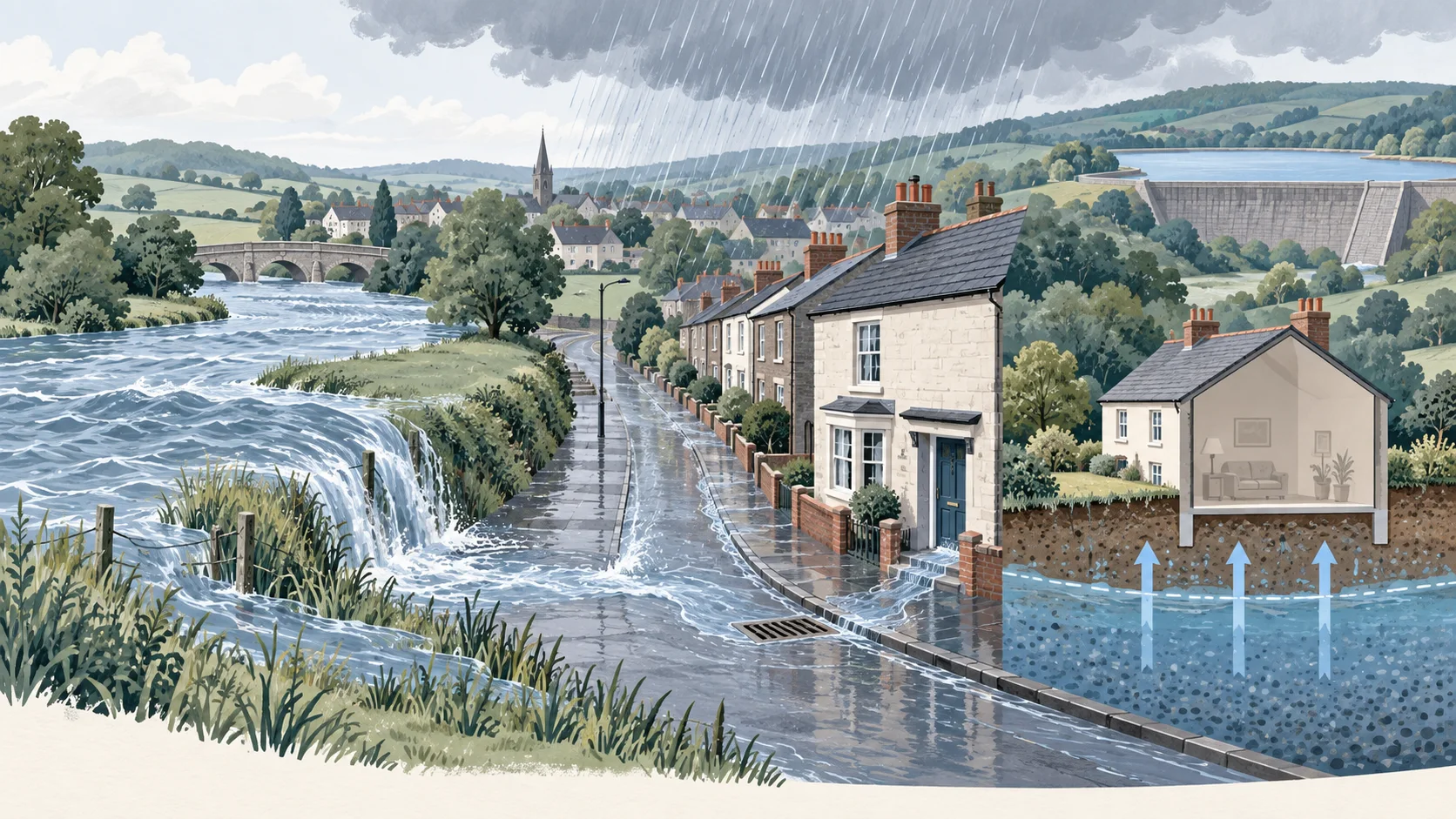
The four types of flooding in the UK are rivers and the sea, surface water, groundwater and reservoirs. Each has a different cause, and a property can be at risk from one type while being at no risk from the others.
Surface water puts the most properties at risk, groundwater flooding can last for months, and reservoir flooding depends on a dam failing. The four types also differ in whether they appear on a flood map at all, which is why a check of one map can miss a real risk.
What Are The Four Types Of Flooding In The UK?
The four types of flooding in the UK are flooding from rivers and the sea, surface water, groundwater and reservoirs. Planning guidance also lists overwhelmed sewers and drainage systems, canals and lakes, and other artificial sources, but national flood risk mapping covers the four main types.
The four types are compared below.
| Type | What causes it | Properties at risk in England | On a flood map? | Report it to |
|---|---|---|---|---|
| Rivers and the sea | Rivers overtopping their banks; high tides and storm surges | 2.4 million | Yes — Flood Zones and a flood risk band | Environment Agency (main rivers, sea); local council (small rivers and streams) |
| Surface water | Rain that overwhelms drainage systems | 4.6 million | Yes — its own flood risk band; not part of any Flood Zone | Local council; water company for sewers |
| Groundwater | The water table rising to the surface | between 122,000 and 290,000 (an older estimate) | Only where data is available | Local council |
| Reservoirs | A dam or reservoir failing | No separate national count | Yes — a worst-case extent, not a chance | Environment Agency |
A property's flood risk is the combination of all four, and each is checked separately. Floods caused by blocked sewers or burst water mains are the responsibility of the water company, and floods from private drains are the owner's responsibility.
What Is Rivers And Sea Flooding?
Rivers and sea flooding happens when a river overtops its banks after heavy rain, or when high tides and storm surges push the sea onto land. It is the only type that Flood Zones describe.
River flooding is sometimes called fluvial flooding in technical reports; flooding from the sea is often called coastal or tidal flooding. The Environment Agency defines the river case as rivers - where heavy rainfall leads to overtopping of river embankments, and the sea case as the sea - where high tides and storm surges lead to coastal flooding.
Rivers and sea flooding happens along river valleys, estuaries and low-lying coasts. It is measured by river and tide gauges, and the Environment Agency issues flood warnings for it. About 2.4 million properties in England are in areas at risk of it. The sea side is explained in full in coastal flooding.
What Is Surface Water Flooding?
Surface water flooding happens when rain falls faster than drains and the ground can carry it away, so water collects on streets and runs into buildings. It can affect land far from any river or coast.
Surface water flooding is sometimes called pluvial flooding, and in Environment Agency publications it is also described as flash flooding. The Environment Agency defines it as happening where there is so much rainwater that it overwhelms drainage systems.
Surface water flooding happens where rain cannot drain away, including towns and cities with large paved areas. It puts more properties at risk than any other type: about 4.6 million in England. It has its own flood risk band and is not part of any Flood Zone, so a home in Flood Zone 1 can still be at High risk. The causes and the checks are covered in surface water flooding.
What Is Groundwater Flooding?
Groundwater flooding happens when water held underground, the water table, rises to the surface after long or heavy rain. GOV.UK guidance describes it as usually slower than river flooding and able to last for weeks or months.
The signs described in GOV.UK guidance are that water comes up through the ground or the floor rather than through doors; flooding usually happens days, weeks or months after lots of rain; it is usually slower than river flooding; it may last for weeks or months. Groundwater flooding can persist for days, weeks or even months, and Underground rooms, such as cellars and basements, are particularly at risk.
Groundwater flooding happens most often in chalk areas: Groundwater flooding is more likely where there is chalk under the ground (the bedrock), and it also occurs in sand and gravel in river valleys. The Environment Agency's national flood risk assessment does not include it, because there are too many gaps in our understanding and evidence for groundwater flood risk, so the only national figure is an older estimate of between 122,000 and 290,000 properties at risk. Where the data exists and what it shows is covered in groundwater flooding.
What Is Reservoir Flooding?
Reservoir flooding happens when a dam or reservoir fails and releases the water behind it. The Environment Agency describes a reservoir failure as a very unlikely event, and its maps show the area that could be affected rather than a chance of flooding.
The Environment Agency's reservoir flood maps show where water may go in the unlikely event of a dam or reservoir failure. They cover two scenarios: a 'dry-day' scenario, flooding if the dam failed when rivers are at normal levels, and a 'wet-day' scenario, how much worse it might be if a river is already in an extreme natural flood. Natural Resources Wales states the same principle for Wales: "We do not provide a risk level for flooding from reservoirs. We show the worst-case scenario."
Reservoir flooding affects land downstream of a reservoir. The Environment Agency updated the flood maps for 1,865 large raised reservoirs in England. Because the maps show a failure scenario rather than a likelihood, being inside a reservoir flood extent does not mean a home is likely to flood. How to read these maps is covered in reservoir flooding.
Which Type Of Flooding Causes The Most Damage In The UK?
No official figure splits the cost of UK flooding by type. By the number of properties at risk, surface water flooding affects the most: about 4.6 million in England, against 2.4 million from rivers and the sea.
Groundwater flooding does its damage over time, because it can persist for days, weeks or even months. The total cost is large whatever the source: the Environment Agency estimates economic damages from all floods in England and Wales between January 2016 and November 2019 at between £504 million and £924 million, with a best estimate of £708 million, and the average insurance claim per household after Storms Ciara and Dennis in 2020 was £32,000.
Many properties face more than one type at once: the previous national assessment found around 642,000 properties at risk from rivers, the sea and surface water together.
Which Types Of Flooding Appear On A Flood Map?
Rivers and the sea, surface water and reservoirs all appear on official flood maps, but in different forms, and groundwater appears only where data is available. Flood Zones, the map used for planning, show rivers and the sea alone.
What each official map shows is set out below.
| Map | Rivers and the sea | Surface water | Groundwater | Reservoirs |
|---|---|---|---|---|
| Flood Map for Planning (Flood Zones) | Yes, ignoring defences | Shown alongside, not part of the zones | Not part of the zones | Not part of the zones |
| Check your long term flood risk (flood risk bands) | Yes, with defences | Yes | Where data is available | Yes, as a worst-case extent |
| Environment Agency national assessment | Yes | Yes | Not included | Not included |
The gap between the maps is where most confusion starts. A home can be in Flood Zone 1, the lowest planning zone, and still carry a High flood risk band for surface water, because surface water was never part of a Flood Zone. The full explanation of that difference is on why a Flood Zone 3 house can be Low risk.
How Do You Check Which Types Affect A Specific Address?
Enter the postcode into the checker on this site to see the flood risk band for rivers and the sea, surface water, groundwater and reservoirs in one result, alongside the planning Flood Zone. The same information is published by the Environment Agency on GOV.UK for England.
A full check of one address covers four steps:
- Check the flood risk band for each type, not only for rivers and the sea.
- Check the Flood Zone, remembering it covers rivers and the sea only.
- Ask the local council about groundwater and past flooding in the street, since groundwater data is incomplete.
- Look for signs on the property itself, such as tide marks, damp cellars or flood-resistant fittings.
All four types for one postcode appear together through check the flood risk of any UK postcode.
Sources (Verified 16 Sep 2026)
| Claim | Source |
|---|---|
| Definitions of river, sea and surface water flooding; 2.4m and 4.6m properties; groundwater 122,000–290,000 and "not updated for some time"; groundwater excluded; 642,000 multi-source; damages 2016–2019; £32,000 average claim | Environment Agency, National assessment of flood and coastal erosion risk in England 2024 |
| Groundwater signs, chalk, cellars and basements | GOV.UK, Groundwater flooding |
| Full list of flood sources | Planning Practice Guidance: Flood risk and coastal change |
| Who to report each type to | GOV.UK, Report a flood or possible cause of flooding |
| Reservoir scenarios; unlikely event; 1,865 large raised reservoirs | Reservoir flood maps: when and how to use them · EA news: reservoir flood map upgrade |
| Wales: no risk level for reservoirs | Natural Resources Wales, Different types of flood risk |
| Long term flood risk service covers groundwater "where data is available" | Check the long term flood risk for an area in England |